 Nederlands
 Dansk
Dansk Österreichisch
 Po Polsku
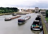


Community Scharnebeck
Scharnebeck is a community in the rural district of Lüneburg in Lower Saxony and is situated west of the nature reserve Elbufer-Drawehn.
The joint community Scharnebeck with a population of nearly 15.000 and has a surface area of 135 sqkm it is embedded in a net of ditches, becks, rivers and channels. It is formed by agriculture and exhibits clear landscape's opposites. The Elbe as northern border river of the joint community Scharnbeck gives the low lying Elbe marsh its face. In the south of the joint community near Scharnebeck and Rulltorf the Elbe marsh merges to the high lying Geest. Opposites, which emerged decades and centuries ago also in farming structures are gone today. The people in the joint community Scharnebeck have an intact infrastructure with all social, cultural, sportive and economical facilities available to them.
Basic data
Federal state: Lower Saxony
Rural district: Lüneburg
Joined community: Scharnebeck
Altitude: 7m above sea level
Surface area: 26,88km²
Citizens: 3.198 (31. Dec 2009)[1]
Population density: 119 citizens per km²
Postal code: 21379
Prefix: 04136
Licence plate: LG
Municipality key: 03 3 55 033
Address:
Gemeindeverwaltung:
Marktplatz 1
21379 Scharnebeck


